(Singapore, 18.06.2026)As rising seas and more extreme weather threaten coastal cities worldwide, Singapore 一 a low-lying island city state 一 is accelerating efforts to protect its shores, drawing lessons from both cautionary tales and exploring all possible solutions including the sophisticated poldering option of the Netherlands.
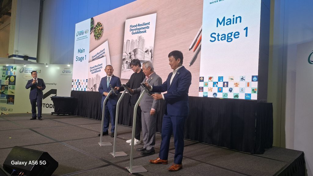
Kicking off the Southeast Asia symposium on coastal protection on the last day of the four-day Singapore International Water Week 2026, Senior Minister of State for Sustainability and the Environment Zaqy Mohamad framed the challenge in stark terms.
“Thirty per cent,” he said. “That is the share of Singapore’s land that could be chronically flooded or submerged if it did not act on sea-level rise.”
The figure reflects the precarious situation that nearly one-third of Singapore sits less than five meters above mean sea level. With major infrastructure such as Changi Airport, the nation’s ports and key industrial facilities located along the coast, climate change poses a long-term existential challenge to the island-state.
According to Singapore’s Third National Climate Change Study, published in 2024, sea levels around Singapore could rise by as much as 1.15 meters by 2100. In more extreme scenarios, long-term sea-level rise could exceed 2.05 meters by 2150. The threat is projected to be compounded by high tides, storm surges, and increasingly intense rainfall events.
Singapore has already experienced incidents of coastal flooding, including inundation at East Coast Park in January 2023.
To illustrate what is at stake, Mr Zaqy compared Singapore’s situation with two famous coastal cities: Venice and Amsterdam.
Venice, built on water and renowned for its canals and historic architecture, has struggled for decades with land subsidence and rising seas. Flooding events known as “Acqua Alta” have occurred more frequently. Although a flood-barrier system was first proposed in the 1980s, it was only completed in 2020. By then, damage and disruption had accumulated over decades.
Amsterdam offers a contrasting example. After a devastating storm in 1953 killed more than 1,800 people and inundated much of the country, the Dutch embarked on the Delta Works, one of the world’s largest coastal-engineering programmes. The project took decades and billions of dollars to complete but transformed the Netherlands into a global leader in flood management and coastal protection.
“Singapore’s answer has to be similar to Amsterdam’s,” stressed Mr Zaqy. “Not because we have no choice, but because we have made a choice to govern with the political will to act now and protect the coastline that our children will inherit.”
That commitment is increasingly visible in policy and infrastructure planning.
Earlier this year, Singapore’s Parliament passed the Coastal Protection Bill, establishing clear responsibilities for coastal landowners and requiring compliance with national coastal-protection standards. The legislation is now supported by a Code of Practice on Coastal Protection launched during this Singapore International Water Week, which sets out requirements for the planning, design, operation and maintenance of coastal-defense systems.
At the same event, authorities also launched a Flood Resilience Development Guidebook aimed at guiding homeowners, developers, and property managers. Not highly technical, the guidebook is designed to help both professionals and ordinary residents understand how they can reduce flood risks to buildings and properties.
Singapore’s coastal-protection effort extends well beyond regulations. Since 2021, PUB has been conducting detailed coastal-protection studies around the island to identify the most suitable measures for different stretches of shoreline. By 2026, studies cover around 80 per cent of Singapore’s coastline.
Implementation of major protection measures is expected to begin progressively from the 2030s.
Where possible, Singapore plans to adopt large-scale, centralised coastal-defence systems. One example is the proposed Long Island project, which is centred on creating reclaimed land off the East Coast. Besides generating new land, the project would serve as a protective barrier for vulnerable coastlines stretching from Marina East to Tanah Merah.
Another planned system would protect the Greater Southern Waterfront through a series of coastal barriers linking the mainland, Pulau Brani and Sentosa, providing collective protection for a large section of Singapore’s southern coastline.
Among the most closely watched projects is Singapore’s first large-scale polder on the islet of Pulau Tekong.
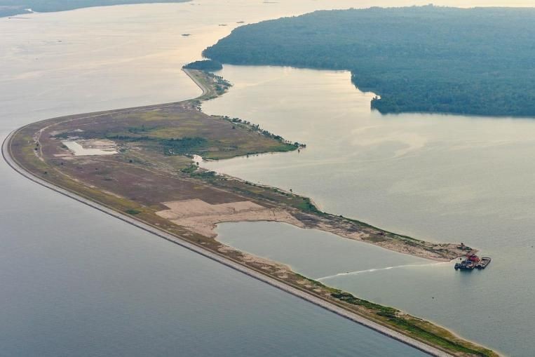
Developed by HDB in partnership with PUB and other agencies, the project created about 800 hectares of new land using a Dutch-inspired empoldering method. Unlike conventional reclamation, which relies on raising land above sea level using vast quantities of sand, a polder allows land to remain below sea level while being protected by engineered barriers and water-management systems.
The Pulau Tekong polder sits approximately 1.2 meters below mean sea level. It is protected by a 10-kilometre coastal dike that rises to six meters above mean sea level.
The system includes stormwater collection ponds, drainage channels, pumping stations, and outlet structures that continuously manage water levels within the protected area. Excess water is pumped over the dike and discharged into the sea when necessary.
Engineers say the approach uses about 50 per cent less sand than traditional reclamation methods, making it both resource-efficient and adaptable. If future sea-level rise exceeds current projections, the dike can be raised further.
The dike itself incorporates multiple layers of protection. A bentonite-cement wall limits seawater seepage, while rock armouring on the seaward side absorbs wave energy. Grass-covered slopes on the landward side help minimize erosion from overtopping waves.
According to project engineers, the dike has a design life of 120 years and has been engineered to withstand exceptionally rare events. The wave-overtopping design standard corresponds to a storm event which returns once in 100,000 years, while slope stability has been designed for water levels associated with a one-in-50,000-year event.
Although the Pulau Tekong polder has attracted public attention, the reclaimed land is not likely to be intended for housing development. By relocating more military activities to Tekong, land elsewhere on mainland Singapore could potentially be freed for housing and other civilian uses.
The suspicion that the polder land will become an HDB estate stems partly from HDB’s role as the lead agency for the reclamation project. However, HDB’s involvement is due to its expertise in land reclamation rather than any housing plans for the site.
As of mid-2026, there has been little new public information about development on the poldered land itself. Instead, the focus has shifted to the polder’s role as a real-world testbed for climate adaptation.
Policymakers and researchers are increasingly studying whether Dutch-style polders could eventually be applied elsewhere in Singapore, particularly in low-lying coastal areas vulnerable to sea-level rise.
Besides physical infrastructure, Singapore is also investing heavily in human expertise.
Mr Zaqy announced that PUB and the non-profit Singapore Water Association’s Coastal Protection Chapter will jointly develop a national skills and competency framework monitoring the full life cycle of coastal-protection projects, from risk assessment and modelling to design, construction and long-term operations.
The framework, expected to be completed in the first half of 2027, aims to groom a new generation of coastal engineers, flood-modelling specialists, and flood-protection managers.
“We know that we will need thousands of trained specialists over the coming decades,” Mr Zaqy said. “And we need to start now.”
The effort mirrors Singapore’s earlier investments in water security, which transformed the country into a global leader in water management and technology.
As climate risks intensify, Singapore’s strategy is becoming clear: build protective infrastructure, strengthen regulations, develop professional expertise and engage the wider community long before disaster strikes.
For Singapore, the challenge is not merely responding to climate change. It is ensuring that future generations inherit a coastline capable of withstanding it.